
Interview with Robert Knap about BIM and the ViiDA platform
News
Fifteen years of celebration took place in the fall of 2023 for one of the key projects in the modern history of VARS BRNO – the National Traffic Information Centre (NDIC).
News
01 December 2023For 15 years, the National Traffic Information Centre has been assisting drivers in the Czech Republic. Take a look at the overview of interesting projects by VARS BRNO that we have also implemented for the Road and Motorway Directorate (ŘSD).
Fifteen years of celebration took place in the fall of 2023 for one of the key projects in the modern history of VARS BRNO – the National Traffic Information Centre (NDIC). The project, which established a successful collaboration with the Road and Motorway Directorate of the Czech Republic (RSD), represented an exceptional challenge. VARS BRNO supplied technical equipment to the newly emerging center in Ostrava, primarily developing a completely new control system that operated successfully until 2017.
Subsequently, its modernization followed, with VARS BRNO once again being the supplier. The modernization ensured the conversion of the system to an open architecture. The system is now modular, scalable, and open for the integration of third-party modules. Thanks to this system openness, the operator can even competitively tender its maintenance. However, VARS BRNO continues to serve as the service partner for NDIC.
NDIC represents the central dispatch of the Road and Motorway Directorate, overseeing traffic on the entire road network under the administration of the RSD, including highways, expressways, and class I roads. The system primarily collects traffic data from various sources, such as traffic detectors, Integrated Rescue System, and others. It verifies this data and creates verified traffic information based on it. This information serves as a data platform for traffic management, road network maintenance, and other activities that the RSD, as the administrator, ensures.
The information provided by NDIC is a current and, above all, reliable source for other recipients of traffic information, such as providers of dynamic navigation for vehicles and others.
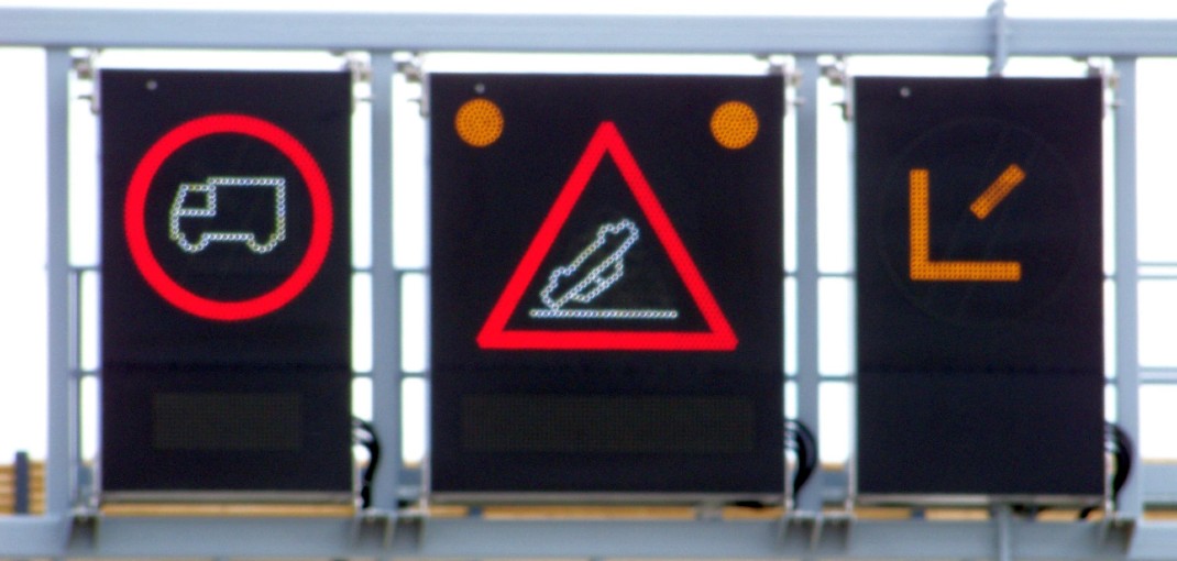
In addition to the data distribution output, the NDIC system itself can manage traffic. Based on predefined scenarios, it controls the traffic information boards on highways. NDIC system outputs are also a crucial source for traffic engineers and traffic planning.
The exceptionally unique project deepened the previous collaboration with RSD and opened the way to a series of further contracts, establishing VARS BRNO as one of the key partners of the Road and Motorway Directorate in the field of ITS. Here is a list of the most significant ones.
This project represents a comprehensive system for centralized planning of continuous maintenance and repairs of roads and structures (bridges). The system operates at several levels, modeling and proposing maitenance plans based on data for individual RSD administrations and branches at the network level. The system optimizes the calculation algorithm by comparing actual repairs with plans, refining the proposal.
A long-term project focused on continuous pavement diagnostics of variable parameters and road defects and evaluation of the quality of road and highways managed by the RSD. VARS BRNO utilizes the unique CleveRA Car measurement vehicle, capable of capturing and measuring the surface at 80 km/h with an accuracy of 1 mm. Based on this data, VARS BRNO generates a detailed report on changes in the surface condition. For the RSD, the measurement of variable parameters is an exceptional basis for planning maintenance, repairs, and reconstructions. In 2023 alone, the VARS BRNO team measured more than 16,000 lane-kilometers of roads and highways under RSD administration.
This telematic monitoring system for tracking traffic flow dynamics on the road network of the Czech Republic consists of a computing module and a presentation layer (display and analytical module). VARS BRNO provided and commissioned the IT infrastructure, ensured data collection from floating vehicles on the network, and continuously compiled a database from collected FCD data for evaluation and display within the System. Applications using FCD data have tens of thousands of users.
The successor to the Road Inspection System ensures a unified record of inspections carried out on roads and defects found during their execution. It provides a unified record of structures and construction objects on roads, a unified record of guarantees and warranty periods, maintenance work records, and other related activities. The system currently has more than 350 internal users and 900 external users.
Among the most widely used GIS applications of the RSD of the Czech Republic. The Geoportal provides an overview of data on the road network from various systems across the RSD of the Czech Republic, allowing a comprehensive view of the managed road network. The application serves both the internal needs of the RSD of the Czech Republic and the professional public. The Video-inventory provides users with photo documentation of roads taken by the Road Databank in Ostrava, including both current and historical images.
ISUD serves the needs of the Centers for Motorway Administration and Maintenance (SSUD). The system is used for efficient maintenance management and control. It allows planning the use of equipment and human resources, monitors vehicles and activities in real-time, maintains online logs of winter and regular maintenance, and provides information for the National Traffic Information Centre (NDIC). It also generates information for the HELIOS economic system. The system has more than 300 active users.
The contract involves the annual documentation of the condition of concrete pavements (CP), focusing on the analysis and identification of locations with microcrack development, including the classification of the condition of identified breach locations. It also includes determining the condition of cross-joint asphalt seals the functionality limitation or damage. The analysis also assesses the condition of edges, including a defect analysis. As part of the analysis, a methodology for evaluating microcracks was created in collaboration with the RSD, enabling monitoring the development of CP breaches over time.
The sets of mobile line control provided by VARS BRNO for the Road and Motorway Directorate significantly contribute to calming traffic in traffic restrictions on highways. The fully automated system, based on sensor data, changes traffic signs to ensure the smoothest possible traffic in restricted areas. VARS BRNO ensured the complete delivery of hardware and software for system control. Each system consists of eight variable traffic signs, two Wavetronix detection radars, four Bluetooth sensors, and ten power points.
The system, part of the Government-approved Unified Transport Information System (JSDI) project in 2005, has been an invaluable tool for providing information on traffic closures for over 15 years. Currently, the system is used by 1810 users, with the legal obligation for road administrative authorities to provide information for both CEU for coordination of closures and for JSDI and NDIC.
The project, implemented jointly with PONTEX spol. s r.o. and Viapont s r.o., was originally developed as part of science and research. The goal was to unify the methodology for evaluating the condition and management system of bridge structures for the administrator of all bridges in the Czech Republic. The system is continuously upgraded and updated, and it is still in use. The main users are regions and municipalities, with the RSD having its own BMS implementation, which records bridges, culverts, underpasses, and other structures. Currently, the system includes 14,485 objects and has more than 700 users.
Historically, the first project for the Road and Motorway Directorate. It is the first system allowing the management of a asset inventory records for motorways.
The ISMaP asset and inventory information system allows for a unified record and localization of data related to assets and activities. It unifies the methodology for recording and evaluating asset conditions. It can record physical features (e.g., pavement layers, guardrails, traffic signs) and variable parameters (IRI, ruts, pavement faults, etc.). The information system created the first object data model for asset recording.
Global Network is a joint project of CEDA Maps, the Road and Motorway Directorate – Road Database Ostrava, and VARS BRNO, involving the creation and updating of a road network model for locating events on the road network. Global Network serves the National Traffic Information Centre and all providers of traffic information providing data for this center.
As the leading consortium of companies PONYSTAR spol s r.o. and Geovap spol. s r.o., VARS is involved in supplying the diagnostic system. The system involves providing diagnostic vehicle equipped with a modern mobile mapping system and software for data processing and publication. The vehicle will be used for ongoing collection of information on the road and motorway network owned by the state. Data will be imported to the PMS.


NEWS